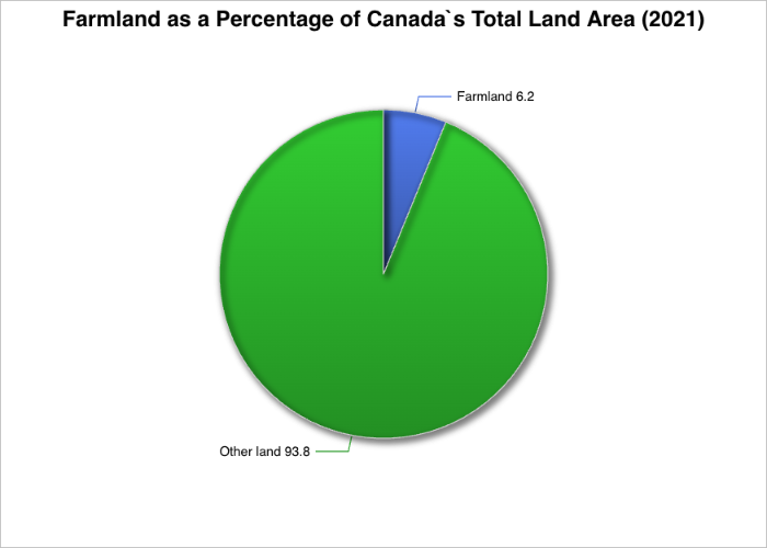
Canada is the second-largest country in the world by total land area, spanning roughly 9,984,670 square kilometres, yet only a small fraction of this vast territory is suitable for agriculture. According to the 2021 Census of Agriculture by Statistics Canada, farmland covers approximately 62.2 million hectares, equal to 622,000 square kilometres. In practical terms, this means that only about 6.2 percent of Canada’s total land mass is used for farming, underscoring how climate and geography sharply limit agricultural expansion across most of the country.
This relatively modest share of farmland stands in contrast to Canada’s reputation as a major global food producer. The explanation lies not in total size, but in where usable land is concentrated and how it is managed.
What Counts as Farmland in Canada?
Farmland in Canada is not a single uniform category. Statistics Canada divides land in farms into several distinct uses, each serving a different function within the agricultural system.
In 2021, cropland accounted for the largest share, totalling 37,876,632 hectares, or about 61 percent of all farmland. Cropland includes land actively used to grow grains, oilseeds, hay, feed crops, vegetables, and other annual or perennial crops. Converted to land share, cropland represents roughly 3.8 percent of Canada’s entire land area, making it the backbone of Canadian agriculture.
READ: Land, Law and Legacy: Agricultural Differences in Upper and Lower Canada
Summer fallow, land intentionally left unplanted for soil recovery, totalled 534,095 hectares, just 1 percent of farmland and only 0.05 percent of Canada’s land mass. While far less common than in past decades, summer fallow remains part of soil management practices in drier regions.
Tame or seeded pasture, used primarily for grazing livestock, covered 4,828,538 hectares, representing 8 percent of farmland and about 0.5 percent of Canada’s land area.
The remaining 18,941,175 hectares, or 30 percent of farmland, fell under “all other land”. This category includes idle land, woodlots, wetlands, farmyards and agricultural buildings. Although not directly planted, these lands are integral to farm operations and environmental balance, amounting to roughly 1.9 percent of Canada’s total land area.
Farmland Is Concentrated, Not Evenly Spread
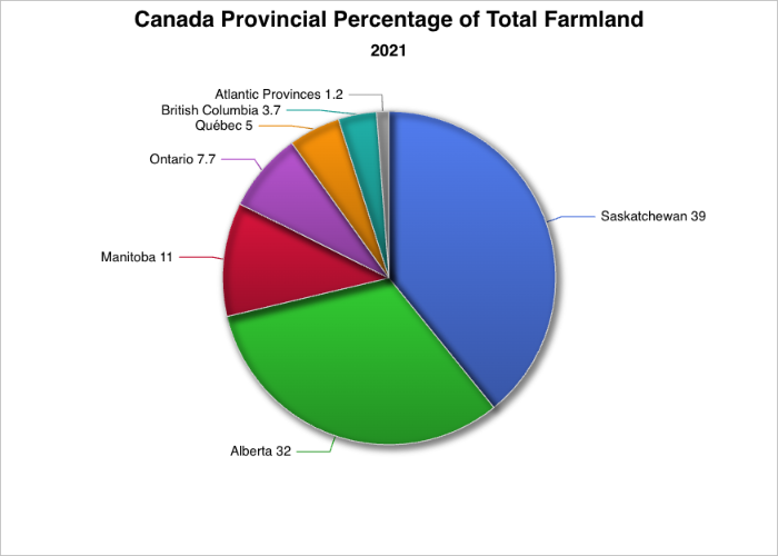
Saskatchewan alone accounts for approximately 24.4 million hectares, representing about 39 percent of all farmland in Canada. Alberta follows with roughly 19.9 million hectares, accounting for approximately 32 percent of the country’s total farm area. Manitoba contributes just over 6.9 million hectares, representing about 11 percent of Canada’s farmland. Together, these Prairie Provinces make up just over 80 percent of all farmed land in Canada, underscoring the Prairies dominant role in national agricultural production.
READ: Saskatchewan Agriculture 2026: Leading the Way in Canola, Wheat, and Pulses
Outside the Prairie Provinces, farmland totals decline significantly. Ontario reports approximately 4.8 million hectares, representing about 7.7 percent of Canada’s total farmland. Québec accounts for roughly 3.1 million hectares, or 5.0 percent, while British Columbia has about 2.3 million hectares, equivalent to 3.7 percent of national farm area.
In Atlantic Canada, farmland is measured in the hundreds of thousands of hectares rather than millions and makes up a relatively small share of the national total. Nova Scotia reports 291,392 hectares, accounting for about 0.5 percent of Canada’s farmland. New Brunswick follows closely with 277,363 hectares, approximately 0.4 percent, while Prince Edward Island, despite its small geographic size, reports 204,234 hectares, representing about 0.3 percent of total farmland. Newfoundland & Labrador has the smallest agricultural footprint in the country, with just over 20,000 hectares, or roughly 0.03 percent of Canada’s farmed land.
Together, the four Atlantic provinces account for approximately 1.2 percent of Canada’s total farmland, highlighting the strong regional concentration of agricultural land in the Prairie provinces.
Why So Little of Canada Can Be Farmed
Several structural constraints limit how much of Canada can support agriculture.
Short Growing Seasons
The length of the growing season, measured by frost-free days, varies widely across the country. Southern Ontario and parts of British Columbia benefit from 180 to 200 frost-free days, while much of the Prairie region operates within 100 to 120 days. In northern regions, growing seasons shrink to fewer than 60 days, making conventional crop farming impractical.
Permafrost
Large portions of northern Canada sit atop permafrost, ground that remains frozen year-round for multiple years. Even when a thin surface layer thaws in summer, soils are poorly drained, shallow and unsuitable for root development. As a result, vast areas of Yukon, the Northwest Territories, Nunavut, northern Québec, and Labrador are effectively excluded from agriculture.
Limited Arable Land
Although farmland accounts for 6.2 percent of Canada’s land area, only about 5 percent is considered truly arable, meaning it can be ploughed and used for sustained crop production. This arable land is largely confined to the Prairies and southern Ontario and Québec.
Latitude Constraints
Farming in Canada is largely restricted to regions south of roughly 55–60 degrees north latitude. Beyond this zone, the combined effects of cold temperatures, poor soils and limited daylight severely restrict crop viability.
Farms Versus Farm Size
Canada recorded 189,874 farms in 2021, but farm numbers do not directly correspond to land area. Ontario has the highest number of farms (48,346), yet far less farmland than Saskatchewan or Alberta. This reflects smaller average farm sizes, diversified production and more intensive land use. By contrast, Saskatchewan and Alberta combine fewer farms with far larger land bases, highlighting the scale-driven nature of Prairie agriculture.
Regional Agricultural Specialization
Each region plays a distinct role within Canada’s agricultural economy.
Prairie Provinces
Manitoba, Saskatchewan and Alberta together accounts for 82.3 percent of Canada’s total farm area and nearly all production of canola, spring wheat and barley. The region also supports over 72 percent of Canada’s cattle and calves, reinforcing its dominance in both crop and livestock production.
Ontario and Québec
Ontario and Québec collectively reported 40.9 percent of Canada’s farms and dominate dairy, hog and pig inventories. Ontario leads national acreage in soybeans, corn for grain, and winter wheat, while also accounting for 61.8 percent of Canada’s greenhouse growing area. Québec, meanwhile, dominates maple syrup production and cranberry acreage.
READ: Why Rice Remains the Backbone of Bangladesh’s Rural Economy
Atlantic Canada
Although representing just over 1.2 percent of total farm area, Atlantic Canada plays an outsized role in specific crops. In 2021, the region accounted for 35.7 percent of Canada’s potato acreage, over 52 percent of lowbush blueberry acreage, and more than 13 percent of apple acreage, supported by a cooler, moist climate well-suited to these crops.
British Columbia
British Columbia is Canada’s horticultural hub, accounting for 22.2 percent of greenhouse, nursery, and floriculture farms, nearly half of national mushroom-growing area, and a significant share of nursery and Christmas tree production.
Agriculture at the Northern Edge
In Canada’s northern territories, farming exists at the margins. Yukon and the Northwest Territories reported a combined 96 farms in 2021, down sharply from 2016. Most farms are small-scale and diversified, with equine operations being the most common farm type. Poultry and egg farms generate the majority of agricultural revenue, despite limited land availability. No farming was reported in Nunavut.
Geological Barriers to Farming in Canada
Beyond climate and latitude, Canada’s underlying geology plays a decisive role in determining where agriculture is possible. Much of the country rests on ancient rock formations that were never conducive to soil development. In these regions, even if temperatures were warmer, the land would remain largely unsuitable for sustained crop production due to shallow soils, poor drainage and limited nutrients.
The Canadian Shield and Southern Ontario
One of the most significant geological constraints is the Canadian Shield, an immense formation of exposed Precambrian bedrock that stretches across northern Ontario, Québec, Manitoba and into Atlantic Canada. In Ontario, this geological boundary explains why farming is concentrated almost entirely in the south. The Shield’s hard granite bedrock lies close to the surface, leaving only thin, acidic soils that are poorly suited for cultivation. As a result, agriculture in Ontario is largely confined to the Great Lakes–St. Lawrence Lowlands, where deeper, glacially deposited soils support field crops, livestock and horticulture.
Even within Ontario, the contrast is stark. South of the Shield, soils are fertile and relatively flat, while shield-dominated regions to the north quickly transition into forest, wetlands and exposed rock, effectively ending large-scale agriculture regardless of climate conditions.
Mountain Systems and Elevation Constraints
In western Canada, mountainous terrain presents another major barrier to arable land. The Rocky Mountains in Alberta and British Columbia sharply limit farming through steep slopes, high elevations, and thin, erosion-prone soils. Agricultural activity in these provinces is therefore concentrated in foothills, valleys, and plateaus, where land is flatter and soils are deeper.
High elevations also introduce colder temperatures, increased runoff, and shorter growing seasons, compounding geological limitations. Even where irrigation water is available, slopes and unstable soils make mechanized farming impractical across large areas.
Soil Formation and Glacial History
Canada’s soils are heavily influenced by its glacial history, which ended only about 10,000 years ago — relatively recent in geological terms. In many regions, glaciers scraped away existing soil, leaving behind deposits that are either too coarse, too compacted, or poorly drained. This is particularly evident in areas dominated by clay plains, rocky till, or waterlogged sediments, which restrict root penetration and oxygen availability.
In contrast, the Prairie provinces benefit from deep, nutrient-rich soils formed from glacial deposits and organic matter accumulation over thousands of years. These soils are among the most productive in the country, explaining why vast areas of Saskatchewan, Alberta and Manitoba remain Canada’s agricultural core
Wetlands, Floodplains, and Drainage Limitations
Another factor reducing arable land is the widespread presence of wetlands and poorly drained landscapes. Large portions of northern and central Canada contain muskeg, peatlands, and marshes, where water saturation prevents soil aeration and crop growth. While some wetlands have been drained historically for agriculture, environmental regulations and the high cost of reclamation limit further expansion.
Floodplains can support agriculture in certain regions, but unpredictable water levels and erosion risks restrict long-term farming in many river systems, particularly where soil stability is low.
READ: Saudi Arabia, the Desert Kingdom That Decided to Feed Itself
These geological limitations, layered alongside climate and latitude, clarify why Canada’s agricultural footprint remains relatively small despite the country’s vast physical scale. Farming is feasible only where soils are deep, terrain is workable, drainage is reliable, and geological conditions allow sustained cultivation — leaving food production dependent on a narrow and geographically specific band of land.
The Canadian Farming Landscape
Although farmland occupies just 6.2 percent of Canada’s total area, it supports a highly productive and regionally specialized agricultural system. This concentration of arable land — shaped more by natural constraints than national size — helps explain both the efficiency and localization of Canadian agriculture. Recognizing the limits of this land base is critical to understanding how Canada sustains food production at home and contributes to global markets in an era of growing environmental pressure.
Where do you farm in Canada, and how do the geography and climate in your region shape what you grow or raise?
Sources
- Government of Canada, Statistics Canada. (2022a, May 11). Land use, Census of Agriculture historical data. Retrieved March 3, 2026, from https://www150.statcan.gc.ca/t1/tbl1/en/tv.action?pid=3210015301&pickMembers%5B0%5D=1.9&cubeTimeFrame.startYear=2001&cubeTimeFrame.endYear=2021&referencePeriods=20010101%2C20210101
- Government of Canada, Statistics Canada. (2022b, May 11). Land use, Census of Agriculture historical data. Retrieved March 3, 2026, from https://www150.statcan.gc.ca/t1/tbl1/en/tv.action?pid=3210015301&pickMembers%5B0%5D=1.10&cubeTimeFrame.startYear=2001&cubeTimeFrame.endYear=2021&referencePeriods=20010101%2C20210101
- Government of Canada, Statistics Canada. (2022c, May 11). Land use, Census of Agriculture historical data. Retrieved March 3, 2026, from https://www150.statcan.gc.ca/t1/tbl1/en/tv.action?pid=3210015301&pickMembers%5B0%5D=1.8&cubeTimeFrame.startYear=2001&cubeTimeFrame.endYear=2021&referencePeriods=20010101%2C20210101
- Government of Canada, Statistics Canada. (2022d, May 11). Land use, Census of Agriculture historical data. Retrieved March 3, 2026, from https://www150.statcan.gc.ca/t1/tbl1/en/tv.action?pid=3210015301&pickMembers%5B0%5D=1.7&cubeTimeFrame.startYear=2001&cubeTimeFrame.endYear=2021&referencePeriods=20010101%2C20210101
- Government of Canada, Statistics Canada. (2022e, May 11). Land use, Census of Agriculture historical data. Retrieved March 3, 2026, from https://www150.statcan.gc.ca/t1/tbl1/en/tv.action?pid=3210015301&pickMembers%5B0%5D=1.6&cubeTimeFrame.startYear=2001&cubeTimeFrame.endYear=2021&referencePeriods=20010101%2C20210101
- Government of Canada, Statistics Canada. (2022f, May 11). Land use, Census of Agriculture historical data. Retrieved March 3, 2026, from https://www150.statcan.gc.ca/t1/tbl1/en/tv.action?pid=3210015301&pickMembers%5B0%5D=1.11&cubeTimeFrame.startYear=2001&cubeTimeFrame.endYear=2021&referencePeriods=20010101%2C20210101
- Government of Canada, Statistics Canada. (2022g, May 11). Land use, Census of Agriculture historical data. Retrieved March 3, 2026, from https://www150.statcan.gc.ca/t1/tbl1/en/tv.action?pid=3210015301&pickMembers%5B0%5D=1.4&cubeTimeFrame.startYear=2001&cubeTimeFrame.endYear=2021&referencePeriods=20010101%2C20210101
- Government of Canada, Statistics Canada. (2022h, May 11). Land use, Census of Agriculture historical data. Retrieved March 3, 2026, from https://www150.statcan.gc.ca/t1/tbl1/en/tv.action?pid=3210015301&pickMembers%5B0%5D=1.5&cubeTimeFrame.startYear=2001&cubeTimeFrame.endYear=2021&referencePeriods=20010101%2C20210101
- Government of Canada, Statistics Canada. (2022i, May 11). Land use, Census of Agriculture historical data. Retrieved March 3, 2026, from https://www150.statcan.gc.ca/t1/tbl1/en/tv.action?pid=3210015301&pickMembers%5B0%5D=1.3&cubeTimeFrame.startYear=2001&cubeTimeFrame.endYear=2021&referencePeriods=20010101%2C20210101
- Government of Canada, Statistics Canada. (2022j, May 11). Land use, Census of Agriculture historical data. https://www150.statcan.gc.ca/t1/tbl1/en/tv.action?pid=3210015301&pickMembers%5B0%5D=1.2&cubeTimeFrame.startYear=2001&cubeTimeFrame.endYear=2021&referencePeriods=20010101%2C20210101
- Government of Canada, Statistics Canada. (2022, June 15). Small-scale diversified farming prominent in Yukon and the Northwest Territories. Statistics Canada. Retrieved March 3, 2026, from https://www150.statcan.gc.ca/n1/pub/96-325-x/2021001/article/00011-eng.htm
- Government of Canada, Statistics Canada. (2011, September 30). Geography. Retrieved March 3, 2026, from https://www150.statcan.gc.ca/n1/pub/11-402-x/2011000/chap/geo/geo-eng.htm
- Government of Canada, Statistics Canada. (2022, June 15). The Daily — Canada’s 2021 Census of Agriculture: A closer look at farming across the regions. Retrieved March 3, 2026, from https://www150.statcan.gc.ca/n1/daily-quotidien/220615/dq220615a-eng.htm